El Nino Adds to Climate Change Puzzle
The Dirt
The "Super" El Nino weather phenomenon is back yet again. Food producers around the world must contend with its consequences – floods, drought and more pronounced weather extremes. Overall, global food consumers aren’t likely to face serious consequences – but local and regional markets may well see some noteworthy weather effects.
Global Food
El Nino Adds to Climate Change Puzzle
The Dirt
The "Super" El Nino weather phenomenon is back yet again. Food producers around the world must contend with its consequences – floods, drought and more pronounced weather extremes. Overall, global food consumers aren’t likely to face serious consequences – but local and regional markets may well see some noteworthy weather effects.
El Nino isn’t just a headline or catchy bit of video on the internet. It’s a serious concern for everyone globally – sometimes deadly serious. The National Oceanic and Atmospheric Administration (NOAA) calls El Nino “arguably the most influential climate driver on Earth.”
What is El Nino?
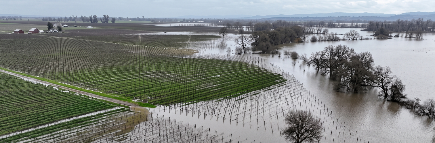
El Nino is a natural phenomenon that results when the surface waters of the eastern Pacific Ocean become warmer than average and easterly winds blow weaker than normal. The result is change in the atmospheric conditions that shape weather patterns around the world. In past El Ninos, we’ve seen a variety of weather effects around the globe – droughts, floods, severe storms, temperature extremes, greater fire risks, polluted waters and a raft of other conditions that result when moisture and temperature patterns are changed from their norms.
There is more at stake with El Nino than just weather conditions. The effects of El Nino shape production of the crops that form the basis of our global food system. Property may be damaged, often catastrophically. People struggler from the extremes with simple human suffering and added risk of disease. Commerce may be affected, shaping the flow of essential goods and services on which we all rely. Of course, farmers could be affected with droughts and/or floods.
Has El Nino begun, and how long will it last?
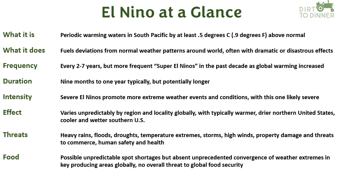
El Nino is nothing new. Since 1950, 28 separate El Ninos have been recorded, occurring on average every two to seven years. El Nino typically lasts for about nine months to a year, although they may vary in intensity and duration. El Nino and its counterpart La Nina both tend to develop during the spring (March-June), reach peak intensity during the late autumn or winter (November-February), and then weaken during the spring or early summer (March-June), according to NOAA.
The National Weather Service states that an El Nino officially begins when water temperatures rise 0.5 degrees Celsius (0.9 Fahrenheit) above normal.
The World Meteorological Organization( WMO) attracted widespread media attention when it predicted an 80 per cent probability of El Nino emerging between June and August, and a 90 percent probability of it forming after that period. But in June, NOAA declared that El Nino has officially arrived, with the ocean temperatures reaching the levels in various parts of the ocean that define it.
NOAA also noted that this El Nino has a 63 percent chance of becoming one of the more severe varieties of the phenomenon – what’s known as a Super El Nino – in which ocean temperatures rise more than 2 degrees Celsius (3.6 degrees Fahrenheit).
The World Resources Institute (WRI) reports that Super El Ninos historically occur every 10-15 years, Five Super El Ninos have been recorded, dating back to an 1877-88 event that left over 50 million dead from widespread damage to agricultural production and the overall ecology, according to government records. The other four have been recorded in much more recent times — 1982-83, 1997-98, 2014-16 and 2023-24.
Does global climate change affect El Nino intensity?
In simple terms, experts worry that this potential Super El Nino could be especially troublesome. Yet, the link between global warming and the frequency, intensity and duration of El Nino is widely debated within the scientific community.
Climate experts at the 2 degrees Institute, point to the effect of the recent warmer-than-average global temperatures. As WRI points out, the last 11 years have been the warmest on record. NOAA also notes that 10 of the warmest recorded years have occurred between 2015 and 2024. Since 1982, NOAA adds, global temperatures have been increasing by 0.2 degree Centigrade (0.36 degrees Fahrenheit) per decade – more than three times the average decade increase dating back to 1850.
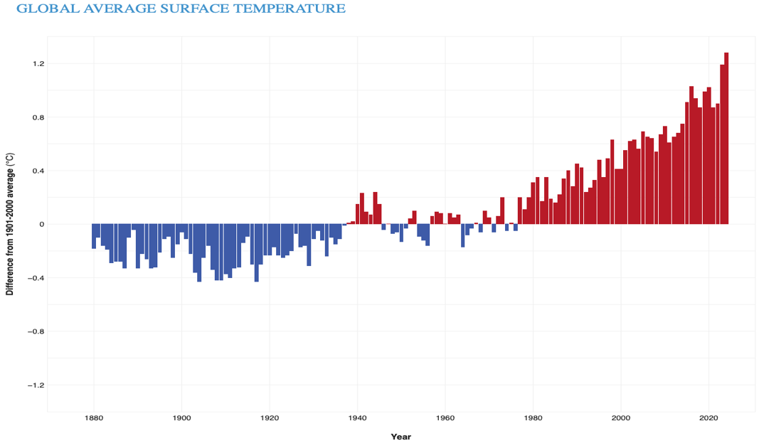
One observer writing in ClimateFactChecks.org captured the sense of certainty possessed by some members of the climate-science community: “Global warming is accelerating the intensity and frequency of El Niño events, with new projections indicating that by 2050, nearly half of these occurrences could reach extreme levels.”
Despite the apparent correlation of El Nino with rising global temperatures, some experts offer a more sophisticated and complex interpretation of the link between climate change and El Nino. Celeste Saulo, secretary general of The World Meteorological Organization, notes that there is no evidence to support the thesis that climate change is increasing the frequency or intensity of El Nino, but rather amplifies its effects.
That is, El Nino’s consequences may become more extreme due to global warming. But global warming does not mean El Nino itself occurs more frequently or become more intense.
How is El Nino likely to affect the weather?
Experts are reluctant to guess just how long this El Nino may last. Most say the phenomenon can persist for up to 18 months – and maybe longer under extreme conditions. For now, most weather experts can agree on one thing: this El Nino can be expected to grow well into the winter of 2026-27.
The precise effects of El Nino are virtually impossible to predict except in very broad terms. Past El Ninos make it possible to speak in generalities about its effects in various regions and areas of the world. But precise projections for specific locations are highly speculative at best, and no two El Ninos are exactly alike.
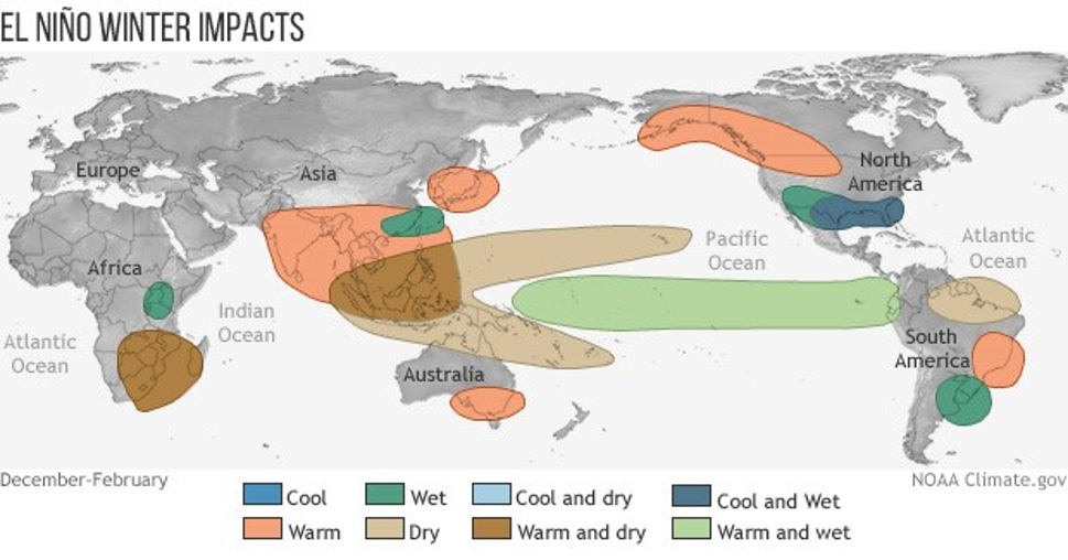
As NOAA observes, “El Niño exerts its largest impacts on the Northern Hemisphere during the winter, typically bringing milder weather to the northern parts of the United States and wetter conditions across the southern United States. In North America, history concurs: expect wetter and stormier weather patterns in the southern United States and drier, warmer weather in the northern parts of the country.
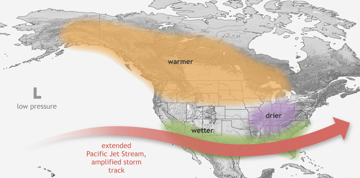
That doesn’t mean everyone is afraid to offer an opinion. For example, Stormbag.com offered its own projections for El Nino’s effects across the United States:
- California (especially Southern): Higher-than-normal precipitation favored. Subtropical jet stream pushes Pacific storms onshore. Atmospheric river risk peaks January-March. Mudslides, debris flows, and coastal erosion all elevated. Watch sloped lots, recent burn scars, and storm drains.
- Desert Southwest (AZ, NM, southern NV/UT): Wetter than average, occasionally dramatically so. Flash flooding in normally dry washes and arroyos. Phoenix and Tucson historically see 2-3x normal December rainfall in strong El Niños.
- Texas / Gulf Coast: Wetter winter favored. Coastal Texas and Louisiana in the firing line for low-pressure systems forming in the Gulf. Spring 2027 flood risk elevated for the lower Mississippi.
- Florida / Southeast: Significantly wetter winter. The Southeast River Forecast Center has documented that strong El Niños drive an average of 23.3 river flood events per year in Florida versus 4.9 in neutral years (1975-2006 dataset, per NWS Tallahassee). Severe weather risk also elevated — El Niño winters produce more low-pressure systems, more clouds, more rain, and more thunderstorm days across the southern tier.
- Ohio Valley: Drier than normal historically. But warmer Gulf moisture passing through can still produce ice events and isolated flooding when fronts stall.
- Pacific Northwest / Northern Rockies: Drier and warmer than average favored. Lower snowpack risk for water managers, higher wildfire setup for 2027.
- Northern tier (Upper Midwest, New England): Warmer than average; precipitation near normal. Reduced snowpack, but ice storm potential when moisture wedges in.
The American GeoSciences Institute also offers predictions of specific regions of the country. Some of their projections include:
- Midwest and Great Lakes: Above-normal temperatures, milder and less frequent colder weather and reduced snowfall levels and ice accumulation.
- Southern Great Plains: Above-normal precipitation, especially in the winter; below normal temperatures, slightly higher probability of snow and sleet.
- Southeast: Above-normal precipitation, with average or drier than normal in the northwestern portion of the region; below average temperatures in the southern part of the region, but near average or slightly above average temperatures elsewhere.
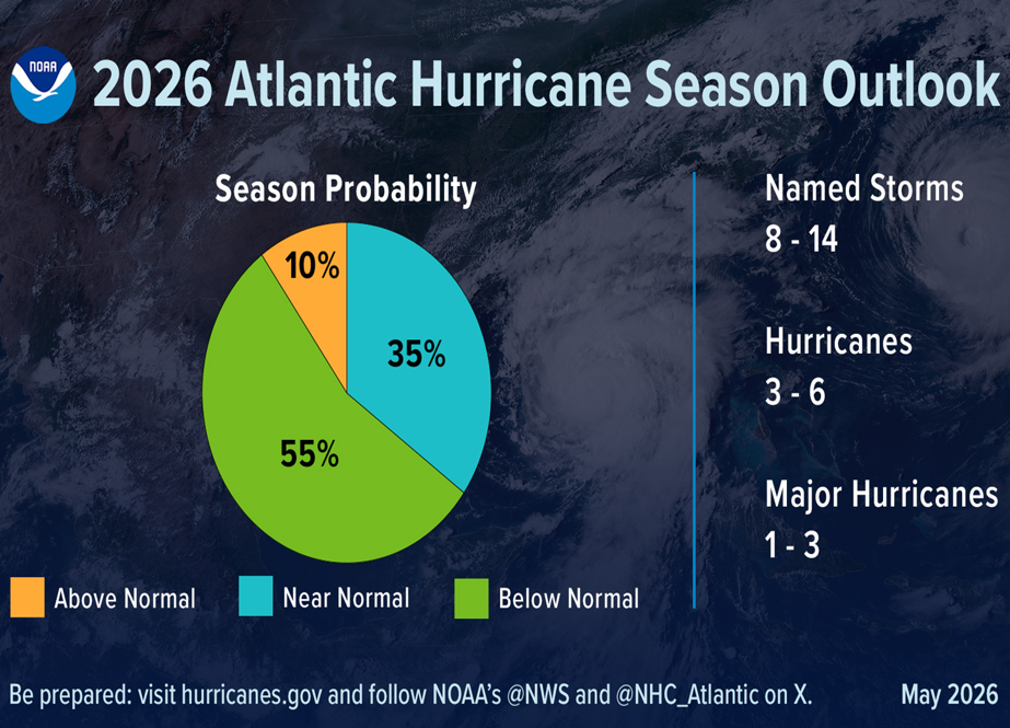 El Nino also has noteworthy effects on hurricane season in both the Atlantic and Pacific Oceans.
In the Atlantic, increases in vertical wind shear tend to inhibit the consolidation of thunderstorms that fuel hurricanes.
Conversely, warmer waters in the eastern and southern Pacific Basin provide more energy for hurricane formation. NOAA projects a 55 per cent probability of a below-average hurricane season in Atlantic waters – and only a 10 per cent probability for above-normal hurricane activity.
On a global basis, history shows certain basic El Nino patterns. Largely as a result of warmer global temperatures, expert projections say, while we can’t pinpoint where and how El Nino will affect specific places around the world, we can reasonably expect to see an increase in the extremes created by El Nino. That is, high temperatures may be higher than we might expect, storms more severe, droughts and floods more pronounced.
What does El Nino mean for global agriculture?
El Nino creates an unavoidable risk for U.S. farmers – especially if extreme conditions emerge at critical times in the growing or harvesting seasons across enough of the key commodity producing areas in the Midwest and mid-South. Similarly, a convergence of extreme weather in other key crop-producing countries or regions of the world could combine to create significant supply issues.
But at this early stage of El Nino, it remains impossible to predict with any degree of accuracy where such events may emerge, or how many, or at what times. It’s a wait and see game – understanding the potential risks, calculating the odds of such a convergence of adverse events, and hoping for the best.
Experts at the Food and Agricultural Organization of the United Nations sound the El Nino alarm, especially for many of the most hard-hit parts of our world in terms of food security and food system resiliency. El Nino usually results in warmer conditions for key food producing areas such as Brazil and Australia. But FAO analysis suggests as much as 80 percent of the adverse effects from drought associated with El Nino will fall on low- and middle-income countries around the world.
FAO’s report contains some sobering language:
The findings point to a high probability of agricultural drought across major producing regions during key growing periods, aligning with regional precipitation forecasts showing below-average rainfall in the coming months.
The risks are sharpest in the Sahel, across Southern Africa, in South and Southeast Asia, and in Central America’s Dry Corridor and the Caribbean, where some agricultural and pastureland areas face more than a 50 percent chance of drought over the coming months.
At the same time, disruptions to shipping through the Strait of Hormuz are pushing up energy and fertilizer costs just as farmers prepare for the growing season.
What about the people?
If good news exists for most food consumers, it rests in the sheer scale of our global food system. Atypical and regional or local weather events may influence the spot availability of some food products in advanced economies, with the expected effect on prices and immediate availability. But the sheer scale of our global food system argues for continued adequate food production for human and animal needs.
Just as important, the system’s amazing ability to connect the places where food is needed and wanted with places where it is available remains a major tool for assuring food security in the face of climatic churn. For most of the world, El Nino poses no immediate threat to our overall food security.
That’s not to say food shortages may occur where damage from severe weather is most acute. The greater threat to humanity may be in the risk of the other forms of devastating suffering created by climate extremes. Droughts, floods, intense storms, property damage and other effects of abnormally severe weather conditions risk far more than inconvenience. They raise the risk of human suffering, from immediate harm from such things as severe floods and storms, as well as the lingering threats of poor nutrition, sickness and disease from localized hunger.
Here are some additional resources:
- To learn more about the complexities of El Nino, start by seeing what the National Oceanic and Atmospheric Administration (NOAA) has to say about it
- For a very detailed analysis of El Nino’s effects on specific areas and locales, visit NOAA’s Climate.gov site.
- For additional information on how El Nino might affect your areas, check out this weather.com page.
The Bottom Line
El Nino is here, and its promises to be a bad one. But our food system remains resilient, and most of the world will continue to enjoy the food security consumers want and need. While climatologists can't predict exactly what will happen they do know that there will be global temperature records; suppressed hurricanes in the Atlantic; the jet stream shifts south bringing wetter and stormier winters; and droughts in Southeast Asia and Australia.
Share this article



Listen to the Dirt to Dinner Podcast